This invention presents a novel system and method for real-time flood risk forecasting that dynamically integrates weather-scale event forecasts with spatially resolved hazard, exposure, and vulnerability data. The system computes the conditional probability of extreme rainfall using hindcasts and observations, processes topographic and socio-economic indicators, and creates high-resolution risk maps at the sub-district level. The output supports early response planning and disaster mitigation.
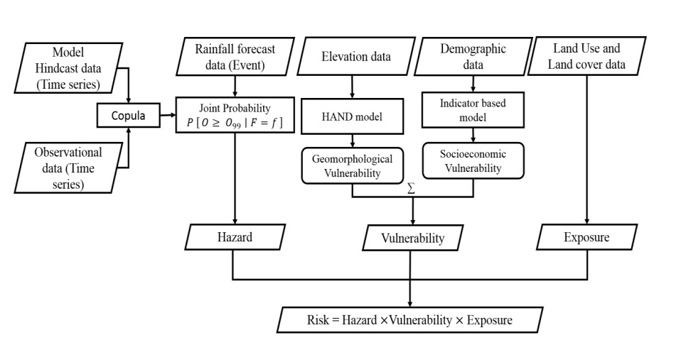

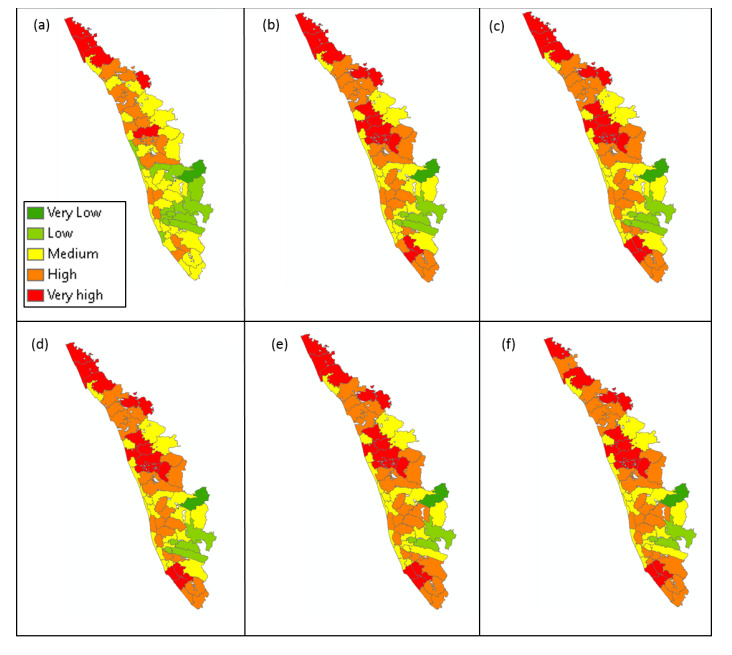
Figure (1) Methodology; (2) Maximum rainfall estimated among all the neighboring grids (grey) and the grid of interest (red) for the forecasts; (3) Typical Flood risk map at a lead time: (3a) 15 days, (3b) 10 days, (3c) 5 days, (3d) 3 days, (3e) 2 days, and (3f) 1 day
Traditional flood forecasting methods lack event-specific precision and do not incorporate regional exposure and vulnerability. These limitations result in delayed or inadequate response to flood risks, especially in the face of increasingly extreme weather events due to climate change. A real-time system that combines forecast skill, hazard modeling, and local vulnerability is needed.
- Event-Specific Hazard Modelling: It calculates probability of extreme rainfall (above 99th percentile) using real-time forecasts and hindcast-observation pairs.
- Dynamic Risk Mapping: This technology generates daily updated flood risk maps for lead times ranging from 1 to 15 days.
- Multifactor Vulnerability Assessment: This technology combines geomorphological (HAND model) and socio-economic indicators at sub-district scale.
- Exposure Analysis: It processes land use and land cover (LULC) data to determine flood exposure.
- Fully Integrated System: This technology involves Modular architecture with hazard, exposure, vulnerability, and risk processor components.
- Administrative-Scale Forecasts: It outputs flood risk maps at the smallest administrative unit (village/sub-district).
The prototype includes processor-integrated modules for hazard prediction (Copula-based probability modeling), vulnerability estimation, and exposure mapping. Risk maps are generated for lead times up to 15 days and visualized at the smallest administrative units. The system architecture supports real-time operation and automated data ingestion.
The method and system are developed conceptually and demonstrated through figures and a defined algorithmic flow. Real-time hazard modeling, statistical integration, and mapping logic are established for application readiness.
5
This technology enables early, localized flood risk identification, facilitating timely evacuation, rescue, and mitigation actions. It strengthens community resilience against climate-induced disasters, particularly in flood-prone regions.
- Environment and Sustainability: The system enhances climate resilience by enabling data-driven flood risk prediction and proactive resource management.
- Societal Resilience and Disaster Management: It supports early warning systems and real-time risk mapping, allowing targeted rescue and evacuation planning at the local level.
- Hydrological Forecasting Services: It integrates rainfall forecasts, hindcasts, and observed data to generate high-resolution flood hazard estimates across multiple time scales.
- Climate Risk Analytics: It introduces a quantitative method to evaluate event-specific flood risk using hazard, vulnerability, and exposure for climate adaptation strategies.
- Urban and Rural Planning Authorities: The flood risk maps assist planners in land-use zoning, infrastructure placement, and mitigation planning based on dynamic risk profiles.
- Government Disaster Management Agencies: It offers an operational tool to identify high-risk administrative units ahead of extreme weather events for prioritized disaster response.
- AI-ML-Based Environmental Risk Platforms: The system provides structured, scalable inputs (e.g., HAND, LULC, socio-economic indicators) for integration into machine learning-based risk forecasting models.
Geography of IP
Type of IP
202021000003
553017