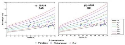
Hydrological studies in regions with sparse rain gauge networks are limited by the availability of rainfall data. Hence, a regionalisation approach becomes critical in modeling extreme events such as floods. A comprehensive framework is put forward for generating regionalised design rainfall time series, which can serve as a vital tool for data-scarce catchments prone to flood disasters. To demonstrate the framework, Jagatsinghpur district, a highly flood prone region in Odisha (India) is selected. An extensive number of parametric and non-parametric families of distribution are used to perform multivariate rainfall frequency analysis. To obtain the regionalised design rainfall (RDR) time series, two optimisation based approaches are proposed. The RDR time series were used as one of the inputs to 2-D MIKE 21 flood model and its performance was assessed by comparing the inundation statistics with those derived by using rainfall from different spatial interpolation techniques. Although a high degree of comparison was noticed with kriging and spline interpolation techniques, the regionalisation method proved to be more dependable and conservative
approach. The proposed framework can help in better estimation of rainfall data,especially for ungauged / partially gauged catchments in developing and underdeveloped countries. In this study, we showed that the framework can be used for extreme events arising due to floods that can support in improved flood management leading to reduction in flood losses. In future, the concept of regionalisation can be incorporated into flood simulation tools along with other existing set of interpolation techniques.
Prof. Subhankar Karmakar