Floods continue to be the most recurring natural disasters and also affect a larger number of people worldwide. Regardless of the progress in technology, the economic loss and deaths due to floods are increasing day by day. Worldwide economic loss of $788.9 billion and 272,251 deaths during 1970-2012 are recorded by World Meteorological Organisation (WMO). Climate change and global warming are reported to exacerbate the situation. Some serious recent floods in India are 2017 Mumbai flood, 2017 Gujrat flood, 2015 Chennai flood, 2013 Uttarakhand flood, 2005 Mumbai flood, etc. Therefore, in order to prevent or reduce impacts of flooding, there is a need for enhanced flood risk mapping and early warning system.
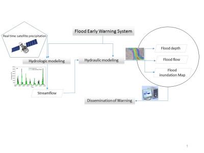
Hydrological models are generally employed to translate rainfall to streamflow over a catchment area, which eventually provides support for real-time flood forecasting, developing early warning system and decision making during flood incidents. Precipitation is the main driving force for most of hydrological models, which can be obtained from field measurements (gauges) or from satellites. The difficulty with meteorological data from gauges is that it has limited temporal and spatial coverage, and also, it only embodies point measurements and does not offer complete coverage of the processes that happen in a catchment. Hence, using (near real time) satellite derived products such as NASA’s tropical rainfall measuring mission (TRMM) as an input to a hydrological model has an advantage for developing flood early warning system, because it can provide good temporal and spatial coverage and they are also readily accessible from scientific agencies.
Our research group works on developing physically based distributed hydrological modeling framework for flood flow estimation and integrating hydraulic models for preparation of flood risk mapping and developing flood early warning system, and its dissemination using Web-GIS framework.
Prof. Manne Jange Reddy