Earth observation image data are mainly characterised by (i) Spatial resolution – the ability of the imaging sensor to focus on very small areas and thereby distinguish between closely spaced features, and (ii) Spectral resolution – ability to observe the targets in a number of narrow wavelength bands of the electromagnetic spectrum.
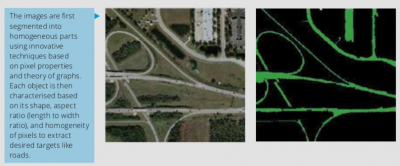
High spatial resolution images allow image analysis based on objects (regions) in terms of their shape, size, and spectral homogeneity, examples which can be seen below:
Hyperspectral images with very high spectral resolution offer opportunities as well as processing challenges for information extraction at sub-pixel level and estimating the image at higher spatial resolution than what the sensor captured (super-resolution).
Prof. B K Mohan