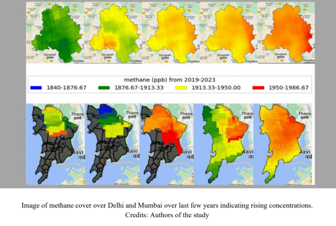
An IIT Bombay study using satellite data shows rising greenhouse gas levels over Delhi and Mumbai and also identifies emission hotspots in these cities.
In 2024, the world experienced its hottest year ever on record. According to the World Meteorological Organisation, global average temperatures in 2024 were 1.55°C above the 1850–1900 baseline — the reference used to track human-driven global warming. This underlines how difficult it will be to meet the Paris Climate Accord of 2016, which set the goal of keeping average global warming below 1.5°C from the baseline. A total of 195 nations, including India, are signatories to the Paris Accord and have pledged to limit greenhouse gases (GHGs) within nationally determined contribution (NDC) levels.
Accurate knowledge of atmospheric greenhouse gases like Carbon dioxide (CO2) and Methane (CH4) is critical to monitoring emission levels and meeting NDC commitments. However, India lacks an extensive network of ground stations to measure GHGs. To bridge that gap, researchers from Indian Institute of Technology Bombay (IIT Bombay), Prof. Manoranjan Sahu and Mr. Adarsh Alagade, turned to satellite data. In a recent study, they demonstrated that remote sensing data can be used to reliably measure the levels of carbon dioxide and methane in metro cities such as Mumbai and Delhi. Using satellite derived measurements the researchers noticed that GHG levels in both cities are on the rise and that they show seasonal and spatial variations. Further, the researchers also developed city-specific statistical models to forecast the level of GHGs.
“By identifying trends and hotspots, satellite-based monitoring gives policymakers evidence to target the worst sources — for instance, prioritising landfill gas capture, traffic management in high-emission corridors, or industrial emissions enforcement — and to evaluate the real-world impact of policies over time,” explains Prof. Sahu regarding the benefit of using satellite-derived data.
Prof. Sahu and Mr. Alagade used data from NASA’s Orbiting Carbon Observatory-2 (OCO-2), which traces carbon dioxide, and the European Space Agency’s Sentinel-5P, which tracks methane. These satellites do not provide direct emission numbers. Instead, researchers relied on specialised algorithms to extract the necessary values from the raw data. To ensure reliability, they validated their satellite readings against the Total Carbon Column Observing Network (TCCON), a network of ground level measuring stations, spread globally, offering highly accurate measurements of CO2 and CH4.
“TCCON provides extremely accurate values and is the standard benchmark used globally to correct and evaluate satellite retrievals. That [comparing satellite-derived measures with TCCON values] validation establishes that the satellites are fundamentally measuring the right quantity and that they reproduce measurements with acceptable errors across a wide set of environments,” says Prof. Sahu. India does not have reliable ground-level measurements. However, the TCCON data are from diverse locations and have enough atmospheric variability. Since their satellite readings align with the diverse data from TCCON, the researchers are confident that their method would apply to the Indian subcontinent.
Using satellite-derived measurements the researchers observed methane and CO2 concentrations over the last few years. This data also alerted the researchers to the emergence of methane hotspots, which were typically around regions with wastewater, landfills or higher industrial activities. The identification of such hotspots, and the risks posed by waste management and rapid urban growth demonstrate how satellite data can play a major role in informing targeted policy interventions. CO2 concentrations were also observed to be rising over the years.
To make sense of the patterns and predict changes in GHG levels, the researchers adapted a statistical model called SARIMA(Seasonal Autoregressive Integrated Moving Average), which is often used for forecasting future values based on past data. SARIMA works much like a weather forecast. In simple terms, it uses recent changes in readings, the jump in the readings from one moment to the next, and the average over a fixed number of previous readings, to predict the next month’s value while also factoring in regular and repeating seasonal cycles. The researchers used the satellite-derived data to fine-tune these three parameters and adapt SARIMA for both Delhi and Mumbai.
With the parameters Prof. Sahu and Mr. Alagade identified for Indian contexts, SARIMA can allow policymakers to test whether measures such as upgrading public transport, tightening industrial norms, or improving landfill management are actually producing measurable reductions in emissions. By comparing real-world post-intervention data with SARIMA’s no-intervention projections, the impact of such policies can be assessed more credibly.
There are, however, limits to using satellites. “Satellites are powerful but not perfect: clouds, dust and city smog can hide or distort measurements; satellites give snapshots rather than continuous local records. All of these factors need careful handling before satellites are used for regulation,” cautions Prof. Sahu. He notes that the most effective monitoring system will combine the strengths of satellites with those of ground stations. “Satellites offer wide coverage and identify emission hotspots, while ground stations capture local detail with precision. Used together, they can reconcile top-down observation with bottom-up measurements, improving the credibility of emission estimates and, in turn, climate policy,” he adds, emphasising the need to expand India’s network of ground-based monitoring sites.
Moving ahead, new tools such as machine learning can potentially enhance the scope of predictions and estimates. “Machine learning (ML) is a powerful tool and will play a big role, but the best future systems mix machine learning with physics-based models, improved satellite sensors, and ground data,” notes Prof. Sahu.
Prof. Manoranjan Sahu, Environmental Science and Engineering Department, Indian Institute of Technology Bombay.